Distance As the Crow Flies Calculator
The straight-line distance between any two places in miles, kilometres and nautical miles. Type a town, address, postcode, ZIP code or coordinates, or click the map.
Free, no sign-up · UK postcodes and US ZIP codes · Road, walking and cycling comparison
Enter two places — or click the map twice — to get the straight-line distance, bearing, midpoint and how it compares with the road.
Radius check — is it within X miles?
Bulk distance calculator — paste or upload a CSV
One pair per line: from,to. Each side can be a place, UK postcode, US ZIP or coordinates in quotes ("51.5072,-0.1276"). Four numeric columns (lat1,lon1,lat2,lon2) also work. A header row is detected automatically.
How this calculator works
Straight-line distance is the shortest path over the Earth's surface (a geodesic). We solve it on the WGS84 ellipsoid — the model GPS uses — with Vincenty's inverse formula, accurate to well under a millimetre. The haversine (perfect sphere) result is shown alongside so you can see the difference, typically up to 0.5%.
Bearing is the initial compass direction from the first point. The midpoint is halfway along the great-circle path. The rhumb line is the longer constant-bearing route that a compass course would follow. Road, walking and cycling distances come from OpenStreetMap routing, and the detour figure compares them with the straight line.
6
units: miles, km, nautical miles, metres, feet, yards
25
stops in one multi-point route
500
rows in the bulk CSV calculator
13
free distance tools on this site
What does “as the crow flies” mean?
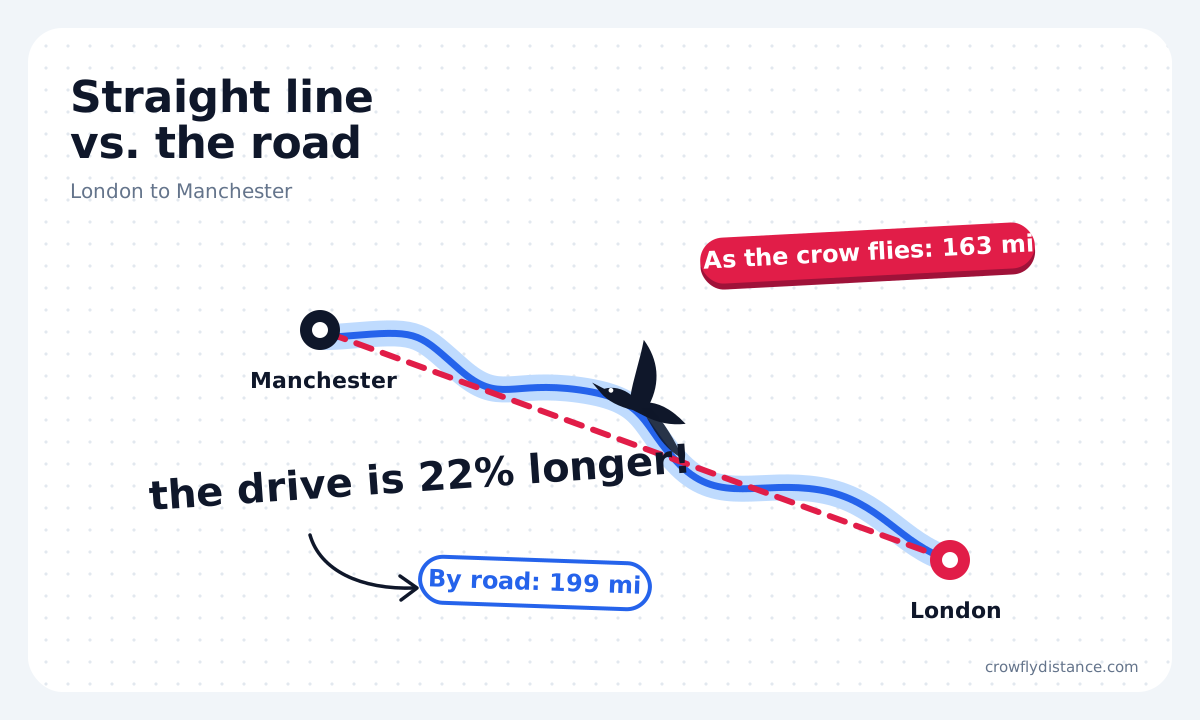
“As the crow flies” is the shortest distance between two places, measured in a straight line over the Earth’s surface. It ignores roads, rivers, hills and borders: it is how far you would travel if you could fly directly from one point to the other.
The phrase comes from the old idea that a crow flies straight to where it is going. You will also see it called the straight-line distance, the direct distance, the beeline or, for flights, the great-circle distance.
People use it to compare how close places really are, to check radius rules such as the 150 air-mile limit for US truck drivers, for property and school catchment questions, and for drone and flight planning.
Crow-flies distance vs driving distance
Roads bend around hills, water and private land, so the drive is almost always longer than the straight line. We measured 10 popular routes from city centre to city centre: the road added between 6% (Dallas to Houston) and 22% (London to Manchester). Around lakes, estuaries and mountains the extra distance can be far bigger.
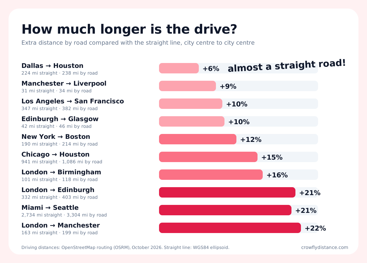
The calculator above fetches the real driving, cycling and walking distance for your own route and shows the detour as a percentage.
Popular distances as the crow flies
Straight-line distances between city centres, measured on the WGS84 ellipsoid. Enter any pair in the calculator for the map, bearing and road comparison.
United States
| Route | Miles | Km |
|---|---|---|
| New York to Los Angeles | 2,451.0 | 3,944.4 |
| New York to Chicago | 712.8 | 1,147.2 |
| New York to Boston | 190.4 | 306.5 |
| Washington, DC to New York | 203.8 | 327.9 |
| Los Angeles to San Francisco | 347.4 | 559.0 |
| Chicago to Houston | 940.7 | 1,514.0 |
| Dallas to Houston | 224.3 | 361.0 |
| Miami to Seattle | 2,734.3 | 4,400.5 |
UK and international
| Route | Miles | Km |
|---|---|---|
| London to Manchester | 163.0 | 262.4 |
| London to Birmingham | 101.2 | 162.9 |
| London to Edinburgh | 332.0 | 534.4 |
| London to Glasgow | 345.5 | 556.0 |
| Manchester to Liverpool | 31.3 | 50.4 |
| Edinburgh to Glasgow | 41.8 | 67.2 |
| London to Paris | 213.7 | 343.9 |
| London to New York | 3,470.5 | 5,585.3 |
How the straight-line distance is calculated
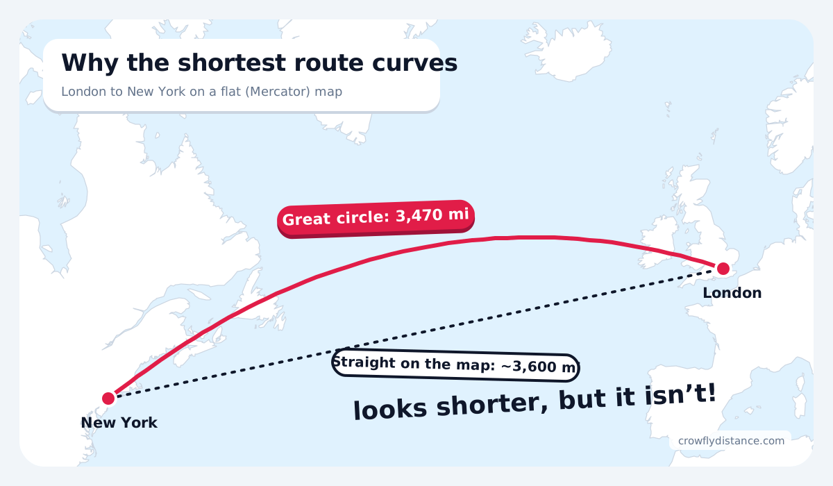
The Earth is round, so the shortest path between two places is a great circle: the line a string makes when you stretch it tight across a globe. On a flat map that path bends towards the pole, which is why London to New York arcs up over Ireland and Newfoundland.
This calculator measures that path on the WGS84 ellipsoid, the Earth model GPS uses, with Vincenty’s formula. For a quick hand calculation, treat the Earth as a sphere and use the haversine formula:
a = sin²(Δφ/2) + cos φ1 × cos φ2 × sin²(Δλ/2)
d = 2R × atan2(√a, √(1 − a))
R = 6,371 km (3,959 miles)
The sphere answer is usually within 0.5% of the ellipsoid answer; the calculator shows both.
More free distance tools
Every tool works with places, postcodes, ZIP codes and coordinates, on desktop and phone.
Maps and your location
- How far am I from…?
Any US state, state line, country, city or home. - Distance to the coast
How far you are from the sea, plus height above sea level. - Radius map
Draw a circle of any size and list the towns inside. - Google Maps distance
Paste Google Maps links or plus codes.
Travel and addresses
- Halfway point calculator
Meet in the middle by straight line or drive time. - Distance between two addresses
Driving mileage, time and cost. - Air miles calculator
Flight distance between airports, multi-leg. - Distance between coordinates
Decimal, DMS and UTM, with formulas.
Maths and conversions
- Distance between two points
The distance formula in 2D and 3D, step by step. - Horizon and line of sight
How far you can see from any height. - Miles to km converter
Length, speed and running pace. - All distance calculators
Every tool in one place.
How to use the calculator
- Type your starting point in the From box: a town, address, UK postcode, US ZIP code or coordinates. Or tap the target icon to use your location.
- Type your destination in the To box, or click anywhere on the map.
- Read the distance as the crow flies and switch between miles, kilometres and nautical miles.
- Check the bearing, the halfway point and the driving, walking and cycling comparison.
- Add stops for a longer route, copy a link to share it, or export it as CSV, GPX, KML or an image.
Frequently asked questions
Is “as the crow flies” the same as straight-line distance?
Yes. Both mean the shortest distance between two points over the Earth’s surface, ignoring roads and terrain. Over long distances it follows a great circle rather than a straight line on a flat map.
How accurate is this calculator?
The maths is accurate to well under a millimetre for the two points used. The bigger factor is which point represents a place: a town name uses its centre, so for an exact answer use a street address, postcode or coordinates.
How much longer is the driving distance?
On the 10 routes we measured, the road was 6% to 22% longer than the straight line. Routes that have to go around water or mountains can be much longer.
Why does the line look curved on the map?
Flat web maps stretch the globe, especially near the poles, so the shortest route over the curved Earth appears as an arc. Short distances around town look straight.
Can I measure a route with more than two places?
Yes. Select Add stop to build a route of up to 25 points. You get the distance of each leg and the total straight-line length.
Can I calculate many distances at once?
Yes. Open the bulk distance calculator under the tool, paste pairs of places or upload a CSV file, and download the results as a spreadsheet.
Which units can I use?
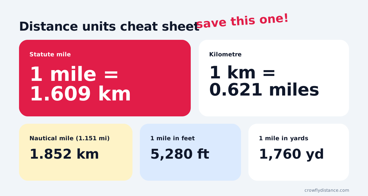
Miles, kilometres and nautical miles, with metres, feet and yards shown for every result. The calculator picks miles or kilometres from your browser language and remembers your choice.